Methods of palaeoclimate reconstruction
Sedimentary rocks are the key to accurate reconstruction of palaeoclimates. The formation of many sedimentary rocks is directly influenced by climate and so they are key indicators of palaeoclimatic variables such as wind direction and strength, rainfall, and atmospheric or oceanic temperature. An understanding of palaeoclimate proxies and their reliability is important for interpreting the cause and effect of major events such as the PTME, as input data and control in numerical palaeoclimatic models (Roscher et al. 2011) and, through the recognition of rain-shadow effects, estimating the palaeorelief of mountain belts (Fluteau et al. 2001).
 Coals, evaporites, aeolian dunes, glacial deposits and fossil plants are some of the most widely used palaeoclimate indicators, and they have offered detailed insights into Permo-Triassic climates.
- Coals indicate former peatlands and lush vegetation growth and are generally taken as proxies for an ever-wet (humid to perhumid) climate, although they also have a strong dependence on basin subsidence and high regional water tables (Falcon-Lang and DiMichele 2010).
- Evaporites are generated under specific climatic conditions of high mean annual temperature and low precipitation, and today form mostly within narrow (25-40o) latitudinal belts. However, they can occur at lower latitudes where topography creates local rain shadows. Like coals, their distribution is strongly controlled by structural geology, with isolated rift basins and continental sags forming preferential sites for evaporative water bodies (Warren 2010).
- Aeolian dune deposits indicate arid climates, but their formation and preservation also require an abundant supply of mobile (dry and unvegetated) sand and basin subsidence.
- The presence or absence of permanent ice is the primary feature of icehouse and greenhouse global climates. Polar ice sheets moving across lowland basins and marine shelves leave behind a distinctive suite of ice-contact facies with high preservation potential. However, glaciers in long-eroded mountain belts leave no direct evidence in the geological record and their former presence is remarkably difficult to establish from linked basin deposits such as fluvial outwash (Smith et al. 1998).
- Plant fossils can be used for climate reconstruction either through an understanding of their ecology based on living relatives or through the leaf stromatal index, which varies inversely with the partial pressure of carbon dioxide (Retallack et al. 2011). This is important because atmospheric carbon dioxide levels are closely linked to global climate (Royer et al. 2004).
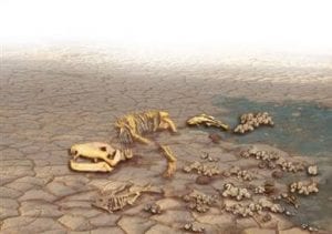
 [Left] A Late Permian gorgonopsian skeleton lies scattered over mud-cracked, drying mud. It might have died as water courses dried up during the dry season.
Clay minerals provide additional crucial data on palaeoclimates. They form by chemical weathering so that the types of clay mineral and their relative abundance in a geological unit are often closely related to climate. Kaolinite, for example, is created by intense chemical weathering in warm, humid climates where silica is leached out, leaving soils enriched in alumina. However, climatic interpretations should always consider additional controls, such as source rock composition, which may include clay-rich soils and formations deposited under a different climatic regime, sorting during transport, and later diagenetic alteration (Yakimenko et al. 2000).
Red beds have long been interpreted as desert deposits, but it is now acknowledged that well drained conditions are probably a more important control on the red colouration than specific palaeoclimatic conditions (Sheldon 2005). Many red beds appear to have formed under warm, humid conditions, sometimes with evidence for strong seasonality.Changes in river channel style calculated from cross-bed or point bar thickness may be an indicator of climate change, although it is important to eliminate alternative external controls such as tectonics and autocyclic behaviour (events responsible for the accumulation of sediments that are part of the sedimentary system itself, such as the size and configuration of a river channel). Fluvial systems in semi-arid settings tend to scale toward the largest flood event, even if these are infrequent. Thus an increase in channel size may not equate to increased climatic humidity (Newell et al. 1999).
Palaeosols, ancient soils, may be used as proxies for precipitation, temperature, and climate seasonality (Retallack 1999, 2012; Sheldon and Tabor 2009; Retallack et al. 2011). Reliable interpretations require an appreciation of how relief, parent material, and vegetation can locally override climate as a primary control on soil type. Carbonates precipitated within soil profiles have played an important role in charting atmospheric δ13C changes through geological time in terrestrial sequences (Royer et al. 2004).
All these sedimentary rock types provide crucial evidence used to reconstruct Permo-Triassic climates and their role in the Permo-Triassic mass extinction.
References
- Benton, M.J. and Newell, A.J. 2014. Impacts of global warming on Permo-Triassic terrestrial ecosystems. Gondwana Research 25, 1308-1337 (doi: 10.1016/j.gr.2012.12.010). Download pdf.
- Falcon-Lang, H.J. and Dimichele, W.A. 2010. What happened to the coal forests during Pennsylvanian glacial phases? Palaios 25, 611-617.
- Fluteau, F., Besse, J., Broutin, J., and Ramstein, G. 2001. The Late Permian climate. What can be inferred from climate modelling concerning Pangea scenarios and Hercynian range altitude? Palaeogeography, Palaeoclimatology, Palaeoecology 167, 39-71.
- Newell, A.J., Tverdokhlebov, V.P., and Benton, M.J. 1999. Interplay of tectonics and climate on a transverse fluvial system, Upper Permian, southern Uralian foreland basin, Russia. Sedimentary Geology 127, 11-29. Download pdf
- Retallack, G.J. 1999. Postapocalyptic greenhouse paleoclimate revealed by earliest Triassic paleosols in the Sydney Basin, Australia. Geological Society of America Bulletin 111, 52-70.
- Retallack, G.J. 2012. Permian and Triassic greenhouse crises. Gondwana Research 24, 90-103.
- Retallack, G.J., Sheldon, N.D., Carr, P.F., Fanning, M., Thompson, C.A., Williams, M.L., Jones, B.G., and Hutton, A. 2011. Multiple Early Triassic greenhouse crises impeded recovery from Late Permian mass extinction. Palaeogeography, Palaeoclimatology, Palaeoecology 308, 233-251.
- Roscher, M., Stordal, F., and Svensen, H. 2011. The effect of global warming and global cooling on the distribution of the latest Permian climate zones. Palaeogeography, Palaeoclimatology, Palaeoecology 309, 186-200.
- Royer, D.L., Berner, R.A., Montañez, I.P., Tabor, N.J., and Beerling, D.J. 2004. CO2 as a primary driver of Phanerozoic climate. GSA Today 14, 4-10.
- Sheldon, N.D. 2005. Do red beds indicate paleoclimatic conditions?: a Permian case study. Palaeogeography, Palaeoclimatology, Palaeoecology 228, 305-319.
- Sheldon, N.D. and Tabor, N.J. 2009. Quantitative paleoenvironmental and paleoclimatic reconstruction using paleosols. Earth-Science Reviews 95, 1-52.
- Smith, N.D., Barrett, P.J., and Woolfe, K.J. 1998. Glacier-fed(?) sandstone sheets in the Weller Coal Measures (Permian), Allan Hills, Antarctica. Palaeogeography, Palaeoclimatology, Palaeoecology 141, 35-51.
- Warren, J.K. 2010. Evaporites through time: tectonic, climatic and eustatic controls in marine and nonmarine deposits. Earth-Science Reviews 98, 217-268.
- Yakimenko, E., Targul’yan, V., Chumakov, N., Arefev, M., and Inozemtsev, S. 2000. Paleosols in Upper Permian sedimentary rocks, Sukhona River (Severnaya Dvina basin). Lithology and Mineral Resources 35, 331-344.

